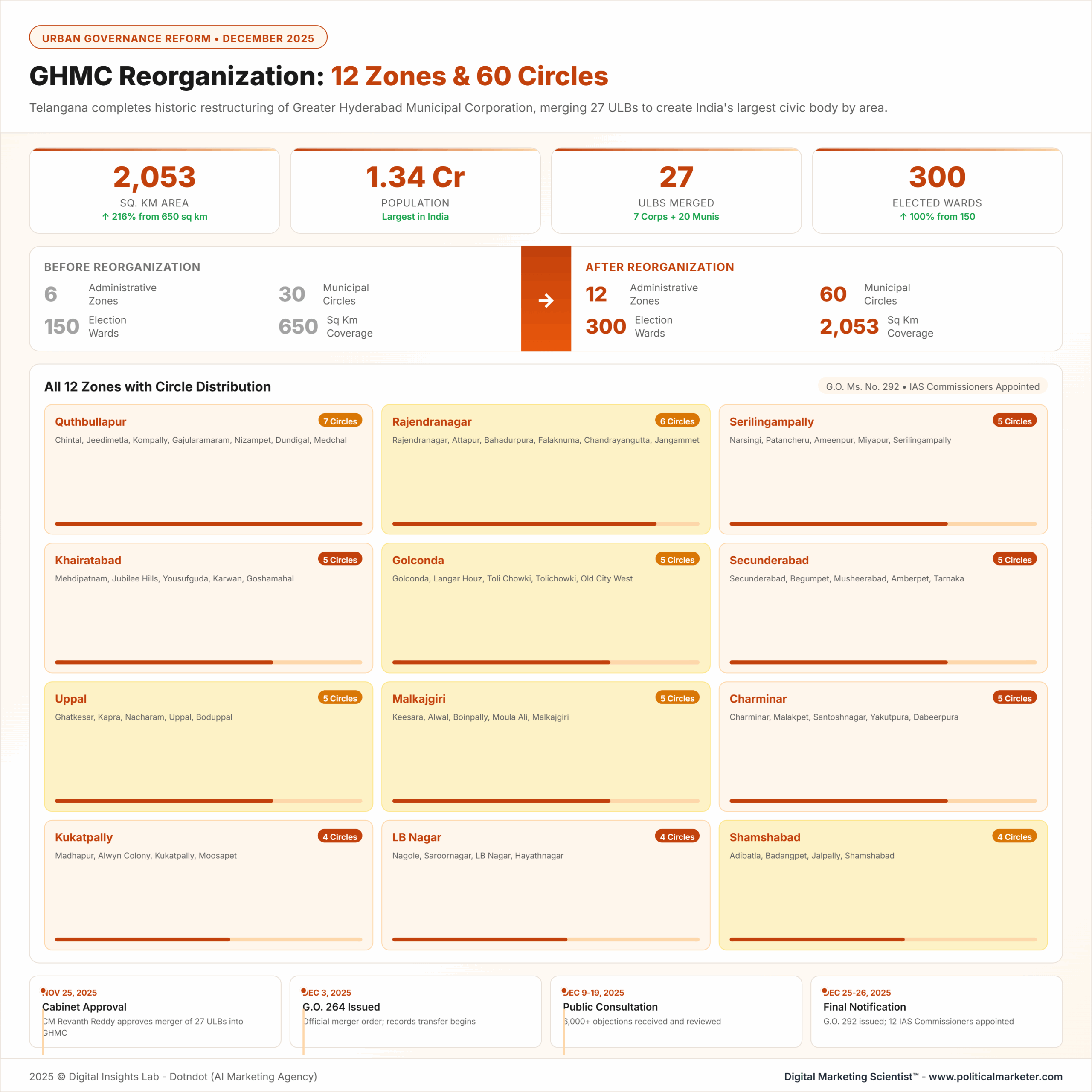
Greater Hyderabad Municipal Corporation (GHMC) was expanded and reorganised in December 2025 to become India’s largest municipal corporation by area and administrative scale, as Hyderabad’s urban growth had outpaced its earlier governance boundaries, service-delivery capacity, and planning mechanisms.
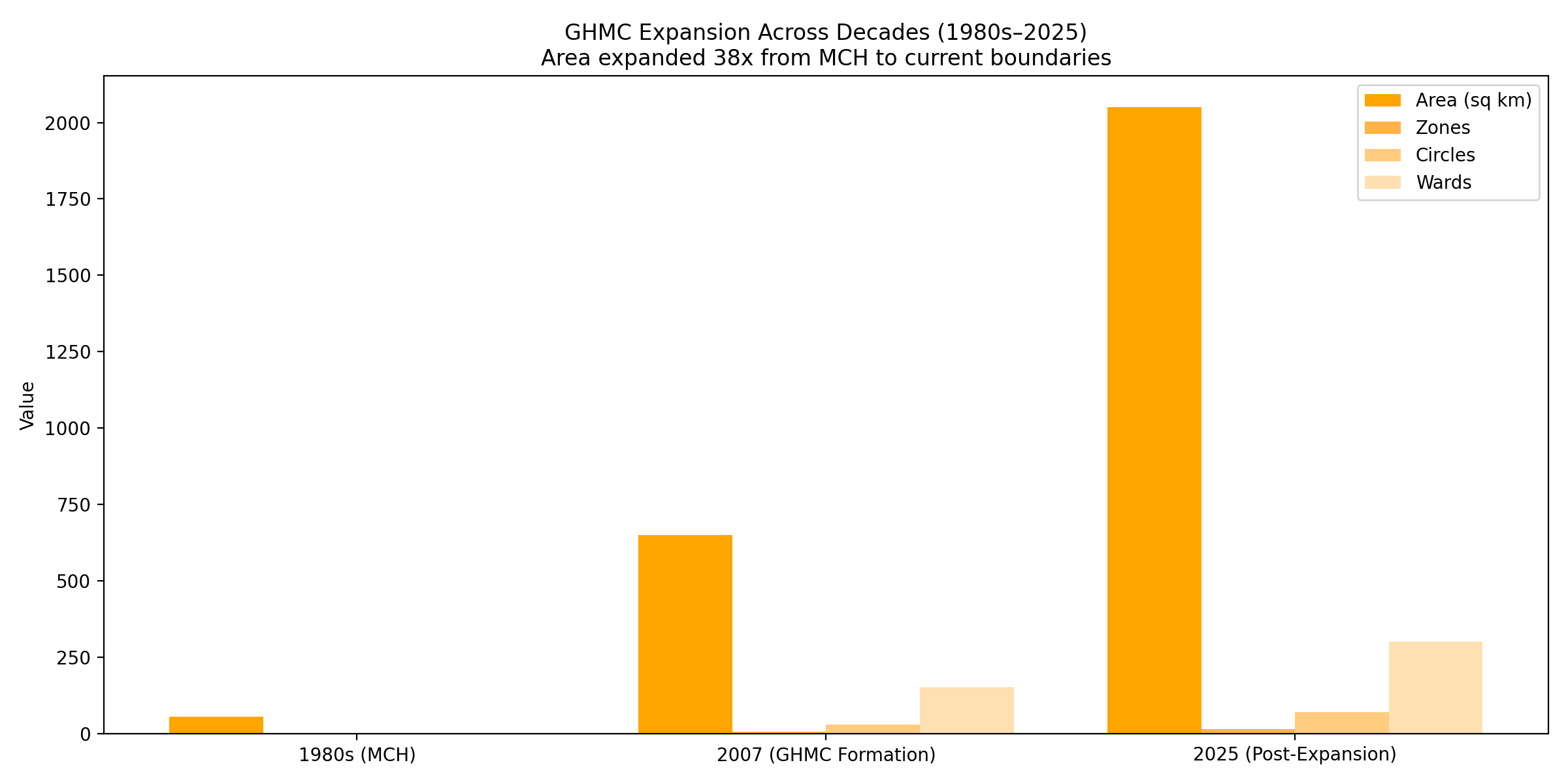
This reform expanded GHMC from approximately 650 sq km to roughly 2,053 sq km, merged 27 Urban Local Bodies, doubled the number of wards from 150 to 300, and increased the number of zones from 6 to 12, creating a unified metropolitan governance structure for over 1.34 crore residents.
What Governance problem was the GHMC expansion trying to solve?
Hyderabad’s metropolitan growth created fragmented urban governance, with core city areas under GHMC jurisdiction and fast-growing suburbs managed by smaller municipalities with uneven capacity. This resulted in inconsistent infrastructure standards, weak enforcement of planning regulations, and poor coordination among transport, drainage, and land-use. According to Telangana urban development reviews between 2018 and 2024, peripheral municipalities consistently lagged GHMC areas in sanitation coverage, road quality, and property tax efficiency.
Why was the old GHMC boundary no longer sufficient?
- Rapid residential and IT-led growth beyond the Outer Ring Road
- Multiple municipal bodies with overlapping responsibilities
- Inconsistent building permissions and enforcement
- Limited disaster response coordination during floods and heatwaves
What is the core solution introduced by the 2025 GHMC Reorganisation?
The solution was to create a single, expanded metropolitan civic authority with decentralised internal administration. The Telangana government, led by Revanth Reddy, merged 27 Urban Local Bodies into GHMC and redesigned its internal structure to decentralize decision-making while maintaining unified planning control.
What structural changes define this solution?
-
Territorial expansion to cover the whole urbanized region
-
Administrative decentralisation through new zones and wards
-
Standardised civic services and taxation across merged areas
-
Integrated urban planning and infrastructure execution
Urban Planning and Infrastructure Implications
The expansion fundamentally alters Hyderabad’s planning paradigm.
-
Peripheral growth corridors are now subject to direct regulation by GHMC.
-
Airport-centric development around Shamshabad can be better synchronised with transport, housing, and commercial zoning.
-
IT and financial districts in the west and north-west benefit from uniform civic regulation across municipal boundaries.
-
Disaster management is enhanced by consolidated command during floods, heatwaves, and public health emergencies.
From Municipal Corporation of Hyderabad to Greater Hyderabad
The Greater Hyderabad Municipal Corporation has experienced several phases of expansion since its inception, reflecting Hyderabad’s transformation from a compact city to a sprawling metropolitan region.
In the 1980s, the Municipal Corporation of Hyderabad (MCH) covered approximately 54 square kilometres and operated with a minimal administrative structure suited to managing a much smaller urban area. April 16
The first major restructuring occurred on April 16, 2007, when the Andhra Pradesh government (then governing Hyderabad before Telangana’s formation) transformed the MCH into the Greater Hyderabad Municipal Corporation by merging 12 municipalities and eight gram panchayats from the surrounding Rangareddy and Medak districts.
This 2007 expansion increased GHMC’s jurisdiction to 625 square kilometres, doubled the ward count from 100 to 150, established six administrative zones, and organised operations across 30 circles.
This earlier merger was significant because it marked the first instance of Hyderabad’s administrative boundaries being extended beyond the municipal corporation’s traditional limits to accommodate the city’s rapid growth and urbanisation.
How large is the expanded GHMC in area and population terms?
The expanded GHMC now covers approximately 2,053 square kilometres, making it the largest municipal corporation in India by area. It governs a population of over 1.34 crore people, based on combined census projections and municipal estimates used in the 2025 delimitation exercise. This places GHMC in the same administrative scale category as global mega-city municipal bodies rather than traditional Indian city corporations.
Which Urban Local Bodies were merged into GHMC?
A total of 27 Urban Local Bodies were merged, including 20 municipalities and seven municipal corporations. These covered major growth corridors across west, south, north, and east Hyderabad.
Examples of merged areas by corridor
- Western belt: Manikonda, Narsingi, Tellapur, Ameenpur
- Southern airport corridor: Shamshabad, Adibatla, Thukkuguda
- Eastern suburbs: Boduppal, Peerzadiguda, Nagaram, Pocharam
- Northern clusters: Medchal, Kompally, Gundlapochampally, Thumkunta
This consolidation eliminated administrative gaps that previously slowed infrastructure and approvals.
How was GHMC Administratively restructured after expansion?
GHMC’s internal administration was redesigned to manage scale without central overload. The structure now balances central coordination with zonal autonomy.
Key administrative changes
- Zones increased from 6 to 12
- Circles have risen from 30 to 60
- Wards have risen from 150 to 300
- Each ward is designed for 40,000–50,000 residents
This restructuring was effected through a Gazette notification dated December 25, 2025, following review of public objections.
Scale of Expansion
The most striking aspect of the Reorganisation is the sheer scale of territorial and demographic expansion.
- Area: Expanded from approximately 650 sq km to 2,053 sq km, extending governance well beyond the Outer Ring Road.
- Population Coverage: Over 1.34 crore residents, bringing urban, peri-urban, and rapidly transitioning semi-rural areas under one civic authority.
- Administrative Reach: GHMC now oversees a contiguous metropolitan region comparable in scale to global mega-cities.
This expansion positions Hyderabad alongside cities that operate unified metropolitan governance models rather than fragmented municipal structures.
The December 2025 expansion far exceeds the 2007 GHMC restructuring in scale 25ative reach, and governance demands. On November 25, 2025, the Telangana Cabinet, chaired by Chief Minister A. Revanth Reddy approved the merger of 27 urban local bodies into the Greater Hyderabad Municipal Corporation. These include 20 municipalities and seven municipal corporations across the districts of Angareddy, Medchal-Malkajgiri, and Sangareddy.
The merged areas are:
Pedda Amberpet, Jalpally, Shamshabad, Turkayamjal, Manikonda, Narsingi, Adibatla, Tukkuguda, Medchal, Dammaiguda, Nagaram, Pocharam, Ghatkesar, Gundlapochampally, Thumkunta, Kompally, Dundigal, Bollaram, Tellapur, Ameenpur, Badangpet, Bandlaguda Jagir, Meerpet, Boduppal, Peerzadiguda, Jawaharnagar, and Nizampet.
The government formally transferred these jurisdictions through Government Order No. 292 on December 2, 2025, bringing them under GHMC administration.
As a result, GHMC’s area expanded from 650 square kilometres to approximately 2,053 square kilometres, increasing its jurisdiction more than threefold. The expanded GHMC now covers an area roughly 2.5 times that of Singapore and nearly as large as Mauritius.
Administrative Reorganisation
To manage the expanded jurisdiction, GHMC underwent a comprehensive internal restructuring.
Zonal Reconfiguration
- Zones increased from 6 to 12
- Newly created zones include:
- Malkajgiri
- Uppal
- Quthbullapur
- Shamshabad
- Golconda
- Rajendranagar
Each zone is headed by a Zonal Commissioner with delegated executive authority, thereby significantly reducing the distance between decision-making and citizens.
Circles and Wards
- Circles: Increased from 30 to 60
- Wards/Divisions: Expanded from 150 to 300
- Ward Design Principle: Population balance of approximately 40,000–50,000 residents per ward
Delimitation was finalised following public objections and revisions and was published in a Gazette notification dated December 25, 2025.
This granular administrative layering is designed to improve monitoring, accountability, and service responsiveness.
The 12-Zone, 60-Circle, 300-Ward Structure
To manage the expanded territory and population, the government restructured GHMC’s administrative framework. The earlier system of six zones, 30 circles, and 150 wards now stands replaced by a 12-zone, 60-circle, 300-ward structure.
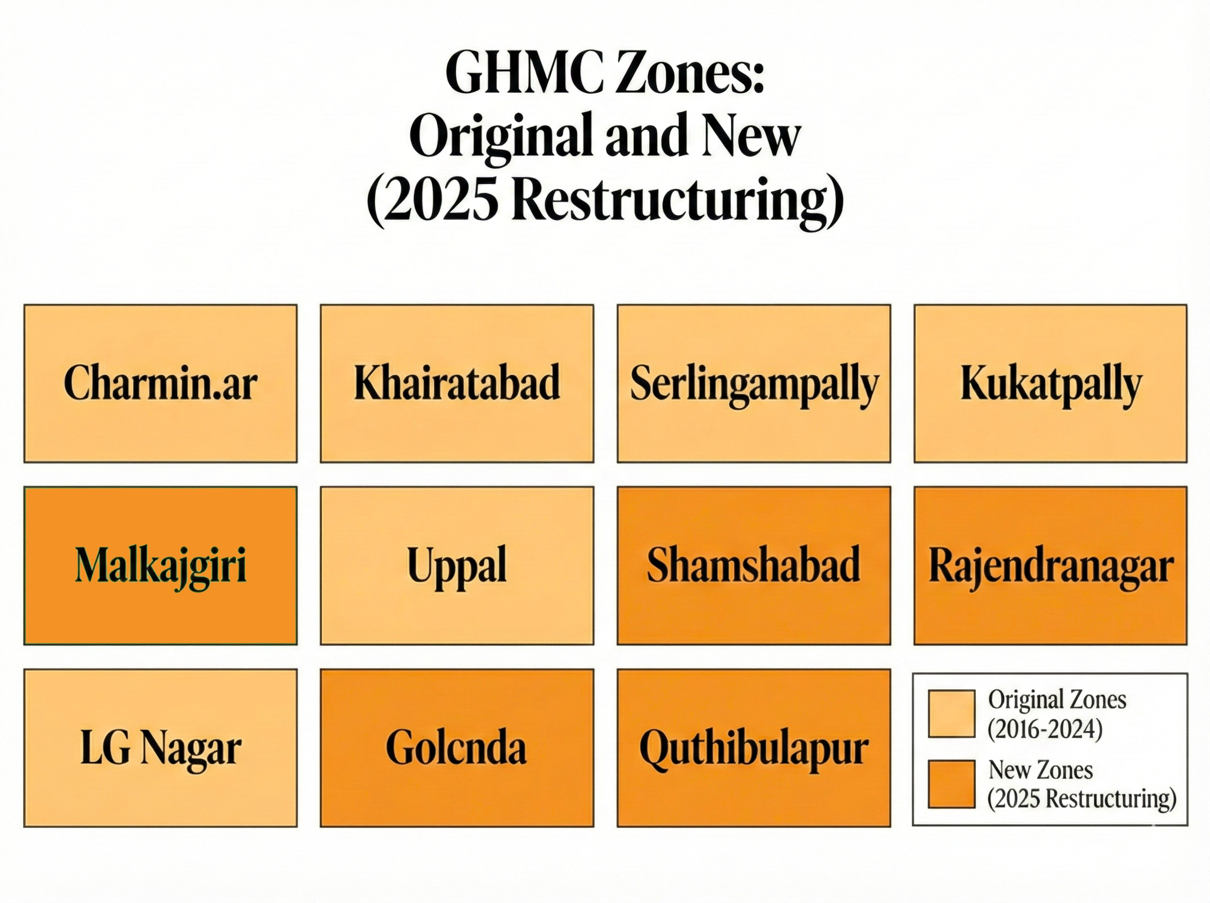
The six original zones remain:
Charminar, Khairatabad, Serilingampally, Kukatpally, Secunderabad, and LB Nagar.
The six newly created zones are:
Malkajgiri, Uppal, Shamshabad, Rajendranagar, Golconda, and Quthbullapur.
Each zone supervises five circles, and each circle manages an average of five wards. This structure seeks to reduce the administrative distance between residents and civic authorities and to improve response times across a much larger metropolitan area.
What are the 12 GHMC Zones created after the Reorganisation?
GHMC now operates through the following zones:
-
Charminar
-
Golconda
-
Khairatabad
-
Kukatpally
-
L.B. Nagar
-
Malkajgiri
-
Quthbullapur
-
Rajendranagar
-
Secunderabad
-
Serilingampally
-
Shamshabad
-
Uppal
Six of these zones are newly created to manage merged suburban regions.
GHMC Zonal Structure December 265
| Zone Name | Status | Zonal Commissioner (as of December 26, 2025) |
|---|---|---|
| Charminar | Retained | S. Srinivas Reddy |
| Khairatabad | Retained | Priyanka Ala (IAS 2016) |
| Kukatpally | Retained | Apurv Chauhan (IAS 2020) |
| L.B. Nagar | Retained | Hemanta Keshav Patil (IAS 2019) |
| Secunderabad | Retained | N. Ravi Kiran |
| Serilingampally | Retained | Bhorkhade Hemant Sahadeorao (IAS 2018) |
| Malkajgiri | Newly Created | Sanchit Gangwar (IAS 2021) |
| Quthbullapur | Newly Created | Sandeep Kumar Jha (IAS 2014) |
| Rajendranagar | Newly Created | Anuraag Jayanti (IAS 2015) |
| Shamshabad | Newly Created | K. Chandrakala |
| Uppal | Newly Created | Radhika Gupta (IAS 2021) |
GHMC 12-Zone Structure: Original vs New Zones
The delimitation of 300 wards required detailed boundary planning. GHMC Commissioner R. V. Karnan stated that officials demarcated ward boundaries using physical and functional markers, including stormwater drains, major roads, railway lines, and identifiable landmarks. This approach aimed to avoid splitting neighbourhoods and ensure administrative clarity.
Each ward targets an average population of 50,000 residents, with a permitted 10 percent variation to maintain representativeness. In practice, disparities remain.
Key differences include:
- Old City areas, with dense settlement patterns, now contain 70-80 wards.
- Several outer zones contain wards with populations of 60,000 to 70,000 residents.
- Some peripheral wards remain geographically large but administratively single to accommodate future population growth.
This uneven distribution reflects planning assumptions tied to anticipated urban expansion in outer zones.
Objectives of the Reorganisation
Multiple interlinked objectives guide the reform:
Uniform Urban Development
Previously, infrastructure quality and civic standards varied sharply between GHMC areas and surrounding municipalities. The merger aims to standardise:
- Road quality
- Drainage systems
- Solid waste management
- Water supply and street lighting
Decentralised Governance
By doubling zones and wards, the administration reduces bureaucratic load per unit, allowing:
- Faster decision-making
- Improved field supervision
- Better accountability of frontline staff
Integrated Urban Planning
Unified jurisdiction enables:
- Consistent land-use enforcement
- Better coordination with master plans
- Rational infrastructure sequencing across the metropolitan region
Resource Mobilisation
A larger tax base improves:
- Property tax collection efficiency
- Infrastructure financing capacity
- Creditworthiness for large urban projects
Leadership and Administrative Appointments
To manage the expanded structure, the government appointed senior administrative officers across key roles.
Jayesh Ranjan, previously Special Chief Secretary to the Chief Minister, assumed charge as Special Chief Secretary for the Metropolitan Area and UrbDecember 25ent portfolio, covering HMDA limits.
On December 25, 2025, the government appointed 12 zonal commissioners. These include a mix of IAS officers and senior officers from local administrative services.
Notable appointments include:
- Sanchit Gangwar, Malkajgiri
- Radhika Gupta, Uppal
- Hemanta Keshav Patil, LB Nagar
- K. Chandrakala, Shamshabad
- Anuraag Jayanti, Rajendranagar
- S. Srinivas ReDecember 26nar
All commissioners assumed office on December 26, 2025, and began establishing zonal offices while overseeing the transfer of records from former municipal bodies.
Why were new Zonal Commissioners appointed, and what do they do?
Twelve Zonal Commissioners, senior IAS officers, were appointed on December 25, 2025, and assumed charge on December 26–27. Their role is to decentralise execution while keeping policy control with the GHMC Commissioner.
Core responsibilities of a Zonal Commissioner
- Supervision of 5 or more circles and about 25 wards
- Sanitation, drainage, roads, and street lighting oversight
- Building permission enforcement and planning coordination
- Revenue collection and grievance redressal
- Disaster response coordination
Addressing Uneven Development and Service Gaps
The government cited persistent disparities in civic services as a primary reason for the merger. Municipalities surrounding the Outer Ring Road faced recurring issues, including damaged roads, inconsistent water supply, sanitation shortfalls, congestion, and environmental stress.
Many of the merged municipalities were created during the earlier BRS administration. They developed independently, without integrated planning with the core city. The government argues that a single civic authority allows uniform service standards for roads, housing, sanitation, water supply, and public amenities.
Unified Planning and Resource Mobilisation
A single GHMC enables coordinated master planning, transport integration, and disaster response across the metropolitan region. Officials argue that consolidation improves financial pooling, strengthens tax administration, and improves disaster preparedness.
An expanded tax base increases fiscal capacity, while unified planning improves the management of traffic congestion, flooding, and pollution through standardized policies and execution mechanisms.
How does the new GHMC Structure improve civic service delivery?
Decentralisation reduces administrative distance between residents and decision-makers. Each ward now covers fewer people than before, enabling faster complaint resolution and tighter monitoring of contractors and field staff.
Expected service-level improvements
- Faster sanitation and waste management cycles
- Quicker drainage maintenance and desilting
- More consistent road repair standards
- Better monitoring of building violations
What is the impact of the GHMC Expansion on urban planning and infrastructure?
Unified jurisdiction allows citywide infrastructure planning rather than piecemeal execution. Transport corridors, drainage networks, and land-use zoning can now be planned across the full metropolitan footprint.
Planning advantages
- Integrated stormwater and flood management
- Coordinated transit-oriented development
- Uniform enforcement of master plans
- Better alignment of housing, jobs, and mobility
How does GHMC compare to other major Indian Municipal Corporations?
The expansion places GHMC in a distinct category relative to peers such as Mumbai and Delhi.
Comparison table: GHMC vs other Indian municipal bodies
| Metric | GHMC (2025) | BMC (Mumbai) | MCD (Delhi) |
|---|---|---|---|
| Area (sq km) | ~2,053 | ~437 | ~1,397 |
| Population (crore) | ~1.34 | ~1.25 | ~1.9 |
| Zones | 12 | 24 ward groups | 12 zones |
| Unified planning | Yes | Partial | Fragmented |
GHMC is now India’s largest municipal body by area under a single civic authority.
What are the Real Estate and economic implications of the expansion?
Inclusion within GHMC generally increases infrastructure certainty, which has historically correlated with higher land values. Developers gain regulatory clarity, while residents receive uniform services.
Likely economic effects
-
Increased property valuations in merged areas
-
Higher but standardised property taxation
-
Improved investor confidence in peripheral zones
-
Stronger infrastructure-led growth
Market Activity
GHMC recorded Rs 759.98 crore in real estate approval revenue between April and August 2025, nearly double the previous year. Developers expect unified regulations and infrastructure upgrades to improve project viability in peripheral zones.
Tax Implications
Residents in merged areas may face tax increases because GHMC rates exceed those of the former municipalities. The MA and UD Department plans further studies before final decisions.
Real Estate and Economic Impact
Positive Effects
-
Greater regulatory clarity for developers
-
Improved infrastructure attractiveness in merged suburbs
-
Increased land and property values in areas previously outside the GHMC limits
-
Better planning certainty for long-term investments
Concerns
-
Higher property tax burdens in newly merged areas
-
Transitional confusion in building permissions and legacy approvals
-
Adjustment challenges for residents used to smaller municipal administrations
What criticisms have been raised against the GHMC Reorganisation?
Opposition parties, including the BRS, and some civil society groups have raised concerns about the speed, depth of consultation, and fairness of ward delimitation.
Key criticisms
-
Process perceived as rushed
-
Fear of political influence in ward boundaries
-
Concerns over centralisation despite decentralisation claims
The government maintains that objections were invited and addressed through formal gazette procedures.
How does the timing relate to the upcoming GHMC Elections?
The current GHMC council term ends in February 2026. The new ward boundaries will define future electoral representation, making the Reorganisation strategically significant for governance and political accountability.
Political and Public Criticism
Opposition parties, particularly BRS, and some civil society groups have raised concerns, including:
-
Alleged haste in implementation
-
Limited consultation in certain localities
-
Potential political motivations in ward delimitation
-
Fears of centralisation overriding grassroots governance
The government counters that public objections were invited and that the urgency of reform reflects Hyderabad’s pace of growth.
Electoral and Governance
The timing of the Reorganisation is significant:
-
The current GHMC council term ends in February 2026
-
New ward boundaries will shape future civic elections
-
Administrative readiness is being prioritised ahead of electoral processes
This underscores the strategic importance of the reform in shaping Hyderabad’s next governance cycle.
The timing of the merger has drawn political scrutiny. Municipal elections are scheduled for 2026, and the Congress government won no Assembly seats in Hyderabad in the 2023 state elections, whereas the BRS secured 16 of 24 seats in the region.
The expansion doubles the number of wards from 150 to 300, increasing the number of corporator positions. Each corporator will control Rs 2 crore in development funds, split evenly between discretionary works and projects approved by the district in-charge minister.
This expansion significantly alters the political map ahead of elections.
Implementation Process and Challenges
Ward Delimitation and Public Objection:
On December 9, 2025, a draft delimitation notification was issued, inviting objections until December 17. The process received approximately 5,900 objections.
Breakdown of objections:
-
Around 30 percent is related to boundary alignment, colony splits, and ward naming.
-
About 15 percent sought additional wards or polling stations.
-
Nearly 50 percent focused on ward maps, boundary clarity, or opposition to the December 16 decision during a special GHMC council meeting on December 16, when corporators from multiple parties raised concerns. Champapet corporator V. Madhusudhan Reddy cited sharp disparities in representation between the Old City and peripheral zones. Medchal MLA Ch. Malla Reddy highlighted the reduction of political representation in his constituency from over 300 local representatives to December 18
The Telangana High Court intervened on December 18, extending the objection deadline and directing GHMC to publish ward-wise maps and population data within 24 hours.
Administrative Capacity Constraints
Officials and critics raised concerns that expanding administrative divisions without commensurate increases in staff strength, planning capacity, and technical resources risks weakening service delivery. GHMC must now manage an area more than three times its previous size, without a proportional increase in workforce or delegated authority.
Record Transfer and Administrative Integration
After the merger notification, GHMC officials took custody of all records from the 27 former municipalities between December 4 and 5, 2025.
This process included:
-
Transfer of minute books and administrative files
-
Closure of municipal bank accounts
-
Transfer of balances to GHMC accounts
-
Documentation of assets, liabilities, deposits, and ongoing schemes
While record transfer is complete, system integration, financial reconciliation, and operational standardisation remain ongoing tasks.
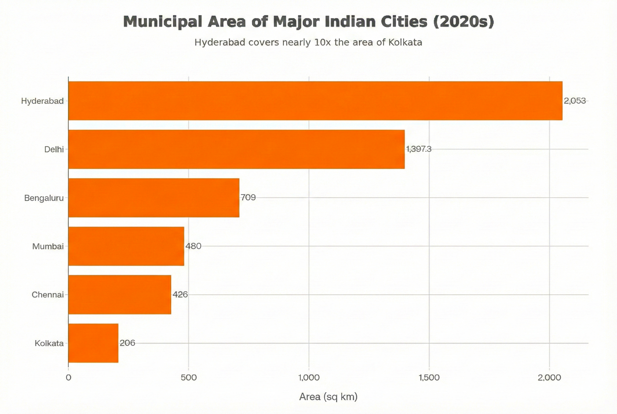
Comparison with Other Major Indian Cities
GHMC Compared by Area
Following expansion, GHMC now exceeds all major Indian municipal corporations in geographic area.
Key comparisons:
-
GHMC: 2,053 sq km
-
BMC (Mumbai): 480 sq km
-
BBMP (Bengaluru): 709 sq km
-
MCD (Delhi, pre-2012): 1,397.3 sq km
-
Chennai: 426 sq km
-
Kolkata: 206 sq km
This places GHMC in a category without domestic precedent.
Functional Fragmentation and Capacity Limits
Revenue Constraints
GHMC’s total annual revenue stands near Rs 5,000 crore, with tax revenue at approximately Rs 2,000 crore. Even after a projected 25 percent increase due to expansion, total revenue would remain around Rs 6,000–6,500 crore.
By comparison, Mumbai’s civic body operates with a budget of roughly Rs 80,000 crore, despite managing a much smaller area.
Fragmented Functional Authority
GHMC does not control several core urban services:
- Water supply and sewerage fall under HMWS&SB’s purview.
- Education and healthcare remain state responsibilities.
- Major roads are under the jurisdiction of HMDA, the traffic police, and the PWD.
- Urban planning remains under HMDA.
GHMC primarily manages waste collection and street sanitation, but often operates with limited capacity. This fragmentation restricts integrated city-level execution.
Water, Infrastructure, and Environmental Pressures
Water Supply and Demand
Hyderabad already faces supply shortfalls. Peripheral areas depend heavily on tanker water. With population projections reaching 1.5 crore by 2035, daily demand may exceed 800,000 MLD.
Wastewater and Sewerage Gaps
Many merged municipalities lack sewerage networks. Residents rely on private treatment systems. While the government approved Rs 14,725 crore for underground utilities, comprehensive sewerage expansion across the entire GHMC area remains unfunded.
Green Cover and Environmental Balance
Urban expansion has reduced blue and green cover over time. Although plantation drives under Haritha Haram have increased green-cover targets, areas such as Rajendranagar and Shamshabad continue to face rapid development pressures.
Balancing growth with environmental protection remains unresolved.
2026 Municipal Elections and Political February 10s
The current GHMC council term ends on February 10, 2026. Elections under the new 300-ward structure will reshape party strategies. The previous 2020 elections saw BRS dominance, BJP gains, and limited Congress presence.
The expanded structure introduces uncertainty for all parties.
GHMC Expansion and Reorganisation
The Greater Hyderabad Municipal Corporation has undergone its most significant structural change since 2007. The Telangana government, led by Chief Minister A. Revanth Reddy of the Congress party merged 27 Urban Local Bodies into the GHMC framework. These include municipalities such as Manikonda, Shamshabad, Kompally, Mandedchal, and others.
This decision expanded GHMC’s jurisdiction from 650 square kilometres to 2,053 square kilometres, extending governance up to the Outer Ring Road. The population under GHMC now exceeds 1.34 crore, making it the largest municipal corporation in India by geographic area.
The restructuring was pursuant to Government Order Ms. No. 292 dated December 24, 2025.
Key administrative changes include:
- Wards increased from 150 to 300
- Each ward now represents approximately 50,000 residents.
- Zones expanded from 6 to 12
- Newly created zones include Malkajgiri, Uppal, Shamshabad, Rajendranagar, Golconda, and Quthbullapur.
- Circles increased from 30 to 60
- Each circle supervises roughly five wards.
The government has stated that the objective is uniform urban development, improved civic services (roads, drainage, and sanitation, and decentralised administration. Additional outcomes include higher HRA and CCA benefits for government employees in newly merged areas and increased land and housing activity in peripheral zones.
Political Implications
The Reorganisation has strong political overtones and is widely viewed as preparation for the upcoming GHMC elections expected in February 2026, following the end of the current council’s term.
Congress Perspective
Congress leaders present the move as an administrative correction intended to manage Hyderabad’s urban sprawl. Politically, the expansion reshapes the voter base.
Key advantages for Congress include:
- Dilution of BRS and AIMIM dominance in the urban core by adding peripheral regions where Congress performed better in recent Gram Panchayat elections and Assembly polls.
- Gains from defections of BRS and BJP corporators, improving Congress’s numerical strength ahead of elections.
- Scope for post-poll cooperation with AIMIM, especially in mayoral selection.
- Projection of Chief Minister Revanth Reddy as the face of a “Mega Hyderabad” vision linked to large-scale investment, technology parks, and global business activity.
A senior Congress leader stated,
“Hyderabad’s growth cannot stop at old municipal boundaries. Governance must reflect reality on the ground.”
Opposition Response and Criticism
BRS Position
The Bharat Rashtra Samithi has strongly opposed the expansion. Party leaders characterize the move as politically motivated and intended to weaken their urban base.
Primary allegations include:
- The expansion serves real estate interests rather than civic needs.
- MLAs, municipalities, and local bodies were excluded from consultations.
- Delimitation lacks transparency and risks higher taxation in merged areas.
- Peripheral regions may continue to face neglect despite formal inclusion.
BRS leaders have framed the move as an attempt to erase the party’s decade-long record of urban governance.
BJP Position
The Bharatiya Janata Party has also opposed the restructuring, though for different political reasons.
Key objections include:
- Absence of an apparent technical or population-based justification.
- Risk of eroding the BJP’s urban gains from the 2020 GHMC elections.
- Concern over a potential Congress-AIMIM understanding that could sideline the BJP in council politics.
A BJP spokesperson remarked,
“Urban boundaries are being redrawn for votes, not governance.”
Process-Related Concerns
Civil society groups, resident welfare associations, and urban activists have raised procedural objections:
- The boundary lines appear arbitrary in several locations.
- Public data used for ward restructuring has not been fully disclosed.
- Timelines for objections and feedback were limited.
The Telangana High Court declined to issue a stay but recorded concerns regarding procedural compliance, leaving scope for future legal challenges.
Projections for GHMC Elections 2026
The expanded GHMC is likely to produce a complex electoral contest.
Key projections include:
- A multi-cornered election involving Congress, BRS, BJP, and AIMIM.
- Congress enters the contest with an advantage, given its recent strength among peripheral voters.
- AIMIM is expected to retain influence in southern zones, particularly in Charminar and the surrounding areas.
- BRS will attempt a recovery by focusing on public dissatisfaction with demolitions, infrastructure quality, and governance.
- BJP remains a wildcard, with potential consolidation in mixed-population zones.
Post-poll scenarios may include:
- A Congress-AIMIM understanding to form the council and elect the Mayor.
- Legal challenges related to delimitation or polling irregularities.
- Negotiations among parties if no single group secures a clear majority.
Broader Political Impact
Control over GHMC carries importance beyond municipal governance. Hyderabad remains Telangana’s economic and political centre.
Longer-term implications include:
- Strengthening Congress’s organisational presence in the state’s most influential urban region.
- Weakening BRS’s historical dominance in Hyderabad civic politics.
- Setting narrative and organisational groundwork ahead of the 2028 Assembly elections.
At the same time, administrative risks remain. Short-term disruptions in service delivery, including delays in documentation and coordination issues in merged areas, could affect public perception.
The expansion improves administrative reach on paper. Its political payoff will depend on execution, funding flow, and the government’s ability to translate structural change into visible civic outcomes.
Future Scenarios: Multiple Corporations
The government has discussed dividing GHMC into three to six municipal corporations in the future. While this could improve decentralisation, critics argue that merging and re-dividing municipalities creates administrative churn.
No final decision exists.
Institutional and Governance Challenges
Scaling Capacity
Managing 2,053 square kilometres requires expanded staffing, technical expertise, and operational systems. Experience shows integration takes years, not months.
Transparency and Consultation
The delimitation process exposed gaps in early-stage consultation. Even senior elected officials received limited advance briefing. While court intervention improved disclosure, procedural trust suffered.
Conclusion
The 2025 GHMC expansion and Reorganisation represent a structural shift in how Indian mega-cities are governed.
By aligning administrative boundaries with actual urban spread, decentralising execution, and unifying planning authority, Hyderabad now operates under a governance model designed for scale, resilience, and sustained growth. If implemented effectively, this reform positions GHMC as a national reference point for metropolitan governance in India.
December 2025 GHMC expansion marks a defining shift in Hyderabad’s urban governance. The city now operates under a single civic authority covering 2,053 square kilometres, structured into 12 zones, 60 circles, and 300 wards.
This scale creates opportunities for unified planning and service standardisation. At the same time, revenue constraints, administrative gaps, and political tensions pose serious risks.
Success depends on:
- Strengthening staffing and operational systems
- Rebalancing functional authority over water, sewerage, and planning
- Expanding revenue through reform or state support
- Coordinating infrastructure delivery across diverse zones
The expansion sets the framework. Whether it delivers better outcomes depends on how governance adapts over the coming years.
GHMC Expansion and Reorganisation: FAQs
What Is the GHMC Expansion Approved in December 2025?
The Telangana government expanded GHMC’s jurisdiction from about 650 sq km to roughly 2,053 sq km by merging 27 Urban Local Bodies and restructuring its administrative framework.
Why Did the Telangana Government Expand GHMC?
You observed fragmented governance, uneven service delivery, and weak coordination of planning in fast-growing suburban areas. The expansion aimed to bring the entire urbanised region under one civic authority.
What Governance Problem Was the Expansion Trying to Solve?
It addressed fragmented municipal control, inconsistent infrastructure standards, weak enforcement of building rules, and poor coordination during floods, heatwaves, and rapid urban growth.
Why Were the Old GHMC Boundaries No Longer Sufficient?
Urban growth extended well beyond the Outer Ring Road, while governance remained limited to the core city, creating service gaps in peripheral areas.
How Much Did GHMC’s Area Increase After Expansion?
GHMC’s area increased from around 650 sq km to about 2,053 sq km, more than tripling its geographic coverage.
How Many Urban Local Bodies Were Merged Into GHMC?
The government merged 27 Urban Local Bodies, including 20 municipalities and seven municipal corporations.
Which Districts Did the Merged Urban Local Bodies Come From?
The merged areas were drawn from the Rangareddy, Medchal-Malkajgiri, and Sangareddy districts.
How Did the Number of Wards Change After Reorganisation?
The number of wards doubled from 150 to 300.
How Did the Number of Zones Change After Expansion?
The number of GHMC zones increased from 6 to 12 to support decentralised administration.
What Are the Six Newly Created GHMC Zones?
The new zones are Malkajgiri, Uppal, Shamshabad, Rajendranagar, Golconda, and Quthbullapur.
How Is Each GHMC Zone Structured Administratively?
Each zone oversees five circles on average, and each circle manages about five wards.
How Was Ward Delimitation Carried Out?
Officials used roads, railway lines, stormwater drains, landmarks, and population data to draw ward boundaries while avoiding splitting neighbourhoods.
Why Do Ward Sizes Vary Across GHMC?
Old City areas have many smaller wards due to high population density, whereas outer zones have larger wards to accommodate future population growth.
What Role Do Zonal Commissioners Play After Expansion?
Zonal Commissioners supervise circles and wards, manage civic services, oversee revenue collection, handle grievances, and coordinate disaster response.
How Does the New Structure Improve Civic Service Delivery?
Smaller administrative units reduce the distance between residents and decision-makers, allowing faster complaint resolution and closer monitoring of field staff.
How Does the Expansion Affect Urban Planning in Hyderabad?
It enables citywide planning for transport, drainage, housing, and land use, rather than fragmented, municipality-level planning.
How Does GHMC Compare to Other Indian Municipal Corporations After Expansion?
GHMC is now the largest municipal corporation in India by area, surpassing Mumbai, Bengaluru, Chennai, Kolkata, and Delhi.
What Financial Challenges Does the Expanded GHMC Face?
Revenue growth has not kept pace with the city’s expansion in area and population, raising concerns about funding infrastructure and services across the expanded city.
What Factors Will Determine Whether the Expansion Succeeds?
Success depends on staffing expansion, better coordination with water and planning agencies, stronger revenue systems, and consistent service delivery across all zones.